

SEMARANG – In order to improve the capability, professionalism and welfare of surveyors in Indonesia, as well as to encourage the implementation of quality survey and mapping products in the new normal era, the Indonesian Surveyors Association (ISI) of Central Java area and Department of Geodetic Engineering, Faculty of Engineering, Diponegoro University (UNDIP) will hold the “XVII Annual Scientific Forum and National Deliberation of Indonesian Surveyors Association” in 2020.
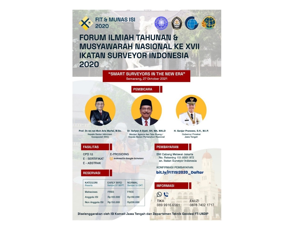
The scientific forum and national deliberation with the theme “Smart Surveyor in the New Normal Era” is scheduled to be held on Thursday, October 27th 2021. Due to pandemic conditions, the implementation which takes place at Patra Hotel & Convention Semarang is carried out in a hybrid way using Zoom Meetings and face-to-face meetings with limited participants. As known, ISI National Conference 2020 is held in 2021 due to the Covid-19 pandemic.
The event committee, Fauzi Janu Amarrohman, said a number of experts and competent officials from various fields would be resource persons at the national seminar. They were presented to explore problems and challenges, as well as to find solutions related to the efforts of smart surveyors in this new normal era of Covid-19. It is hoped that this forum can also contribute to the progress of surveys in Central Java and Indonesia.
The speakers of this event are Dr. Sofyan Djalil S.H., M.A., M.ALD, Minister of Agrarian Affairs and Spatial Planning / Head of National Land Agency; Prof. Dr.rer.nat. Muh Aris Marfai, S.Si, M.Sc, Head of Geospatial Information Agency; and Ganjar Pranowo, S.H, M.IP., Governor of Central Java.
The organizers of the National Conference and Scientific Forum also open opportunities for researchers and academics who are active in the field of surveys to contribute with their research results. “We invite researchers, academics and practitioners to publish the results of research, studies and community service in this forum,” said Fauzi Janu.
Call for paper is open to themes including Land, Spatial Planning and Regional Boundaries; Natural Resource Management; Construction, Infrastructure and Mining; Natural, Environmental and Social Disaster Mitigation; Applications and Innovations of Geospatial Technology; and Education and Profession in the field of Surveying and Mapping.
The committee stated that participants will get a CPD score of 12, e-certificates, e-abstracts and e-proceedings indexed by Google Scholars for presenters. (PR team)
Translated by: Titis (Public Relations)