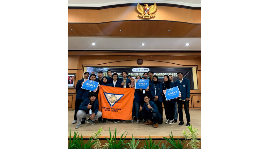
A day full of joy and pride results from the struggle of Geodetic Engineering students of Diponegoro University (Undip), who succeeded in becoming champions in the 2023 GIS Competition. This competition is a national event highlighting the discipline of geospatial science, organized by the Department of Geographic Information Science, Faculty of Geography, Gadjah Mada University (UGM). This event was in conjunction with “The 8th Geoinformation Science Symposium 2023.”
The 2023 GIS Competition consists of two parts: the GIS Competition and the Map Competition. At this event, Geodetic Engineering Undip students achieved the highest in the GIS Competition and won 3rd and Favorite rank in the Map Competition. Map Competition is a competition where final maps are assessed directly by academics and participants in the Geoinformation Science Symposium (GSS).
The “Mavericks” team, consisting of Giant Kusuma Zahra, Rachmad Fajar Setiawan, and Muhammad Said, won 3rd place in the Map Competition with a map entitled “Accessibility of GLAM in Surakarta City using Public Transportation.” Meanwhile, the “Snowden” Team consisting of Citra Hadi Saputri, Alif Marwan Hadid, and Ricko Prihantama Putra won Favorite Champion with a map entitled “Where Have the 21st Century Rice Fields Gone: A Positivism Viewpoint in Demak Regency.”
It did not stop there. The Geodetic Engineering Undip Team also won brilliantly in the 2023 GIS Competition. The finalists in the GIS Competition had to make a 10-minute presentation in front of three judges: Dr. Nur Mohammad Farda, S.Si., M.Cs. (Lecturer at the Faculty of Geography UGM), Ir. Sarono, S.Si, M.Eng (CEO/Founder of TechnoGIS Indonesia), and Edwin Maulana M.Sc (Educational Media Compiler Staff, Parangtritis Geomaritime Science Park).
Extraordinarily, Team “Welas Asih,” Team “LMS,” and Team “Geolnnovators” managed to win 1st, 2nd, and 3rd place in the GIS Competition, respectively. The “Welas Asih” team consisting of Ricko Prihantama Putra, Citra Hadi Saputri, Alif Marwan Hadid, and William Gozali raised the title “Jakarta City Carbon Report Card: Looking at Milestones and Evaluation of Carbon Emission Reduction by Integrating Geospatial Big Data for the 2020-2022 Period as Target Projection 50% Reduction in Carbon Emissions by 2030”.
Next, the “LMS” Team consisting of Rahmat Al-Azizi, Matias Dimas, Sekar Arum, and Farah Nur Amalina raised the title “Utilization of Big Spatial Data and Geographic Information System (GIS) Based on Geo AI in Central Business District Detection of Carbon Emission Levels Digital in Java-Bali.”
Finally, the “Geolnnovators” team consisting of Atri Febriyanto, Candra Dewi Pramesthi, Giant Kusuma Zahra, and Muhammad Fiqri Rahman raised the title “Integration of Geographic Information Systems for Carbon Emission Analysis and Estimation of CO2e Emissions Due to the Use of OpenAI Chatbots: Case Study of Semarang City”.
The success of Geodetic Engineering Undip in the 2023 GIS Competition proves its dedication to continuing to hone its skills and willingness to compete to achieve excellence and exist on the global stage. This achievement is also clear evidence that hard work and teamwork can produce innovation and valuable knowledge in developing geospatial technology in Indonesia. (Ricko Prihantama)